

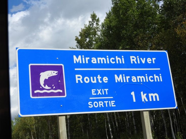
The Miramichi River Route A.K.A Highway 8 is a scenic drive between Fredericton and Miramichi.; I recommend to bit, chew, and digest, this awesome 174 kilometer strip of river and road, one attraction at time. This is not a what do and see in Fredericton or Miramichi but what see and do on the way between both Lets go
Marysville

One of my hobbies is locating Canadian National Historic sites, if you too are a history buff Marysville, is not to be missed.Within Marysville Historic District street parking is non-existent so go to the heritage centers on McGloin Street and park in their lot. Take your lunch to the covered picnic table and eat alfresco. A clean drinking fountain for yourself or your pooch was forward thinking on the designers part. Then stretch your legs with a stroll on the Gibson Trail. Beyond the paved path are signs stating environmentally sensitive area. I walked the narrow worn path along the river bank. White painted trunks of newly planted sapling, were flourishing. Tall thick marsh grass concealed birds, I could hear but not see. A rewarding rejuvenation of the Nashwaak River ecosystem for the nature lover.
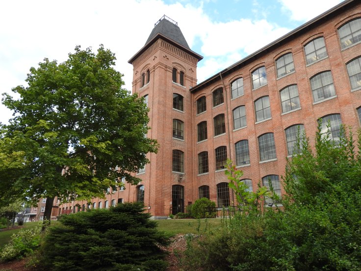
Next up, walk across McGloin street to Marysville Place, the former Marysville Cotton Mill National Historic Site. This five-story brick building is now home to government offices. The National Historic plaque is located beside the entrance door. Circle the structure and be impressed with the 19th century industrial architecture. Unlike other historic district, that have modernized their building to attract the shopping tourists with high-end boutique and cafes, Marysville remains true to its industrial roots, a historians delight, Maintaining its original grid of residential, commercial and industrial sections. The complete district is condensed into the intersections of Canada Drive and Bridge, Morrison, Allen, Downing, White and Mill street.
Next walk over the bridge spanning the Nashwaak River to Veterans Memorial Park. The The Nashwaak Trail runs along this side of the river. There is a cenotaph for our fallen solders and get up close to a six-pounder anti-tank gun on display.


We are not done yet. Cross Bridge Street at the lights and walk up Canada Drive to see the Marysville Historic District National Historic Site Monument, it is maybe 200 meters up the slightly inclined street. If you need a rest there is a bench provided.


Return via a sidewalk alley and venture onto Mill street (a dead-end street) the Nashwaak trail continues along on this side of the road too for you cyclist. View some of the restored homes and former business locations boss Gibson had designed and built for his town.

Return to your car and drive to Royals Field also a local historical site and of interest to baseball fans. Leave McGloin street and turn right onto Bridge street and turn left onto either of Morrison or Downing. You’ll get a chance to drive pass numerous residential brick home of the industrial period. At the top of the hill, is a baseball diamond, not the open field one but the walled off one with a sign perched above it, Home of World Champion series winner Matt Stairs

The main entrance was locked but I could see someone on the field wearing a baseball cap. I stepped in the side gate and said ” hello” I explained, I was a travel blogger doing a piece on Marysville. ” What can you tell me of Matt Stairs? with no hesitation states, “he won his world championship with Philly, but played with several teams over his career.” ‘I understand that this is a historical place. Is there a plaque?’ he nods and ” says on the corner of the building” I ask him his name and he replies. ” Corbin.” (Sorry if I misspelled your name Corbin) “Can I come in and take some pictures? He agrees I thank him and scoot in quick before he changes his mind. I snap some shots of the small historic plaque but the field is the attraction.

It is very professionally presented. I return to Corbin, and say ” I understand there is a big game here tonight?” He says, “Yes, first game of senior men’s championship, it Starts at 7 pm.” I thank him tell him he was very helpful and I head out.
Head down Morrison road this time, and cut across Allen to River road, so you can to say you saw all the historic district. Turn right on Bridge and at the light, turn right on Canada street. We have one more stop, the Gibson Family Plot.

Pay your respects to “Boss” Alexander Gibson and his family, this cemetery is also a historical site. My friends at the Fredericton Regional museum, can tell you more about the Boss.
Keep going north on Canada drive it will transition into Highway 148, a lovely drive along Nashwaak River. We are going to Durham Bridge to hike to Dunbar Falls. Plug Dunbar Road into your GPS
Durham Bridge
It took me two trips here to find the falls, and the second time I attempted four different approaches before finally finding it. My mistakes will save you time, here is how we get there.

Drive up Dunbar road, (it is a gravel road) about 900 meter. Just past the turn, on the right is a dirt road.( shown above) It is wide enough for a vehicle but I wouldn’t drive anything but an ATV on it. Park on Dunbar and walked in. There is a stream with a pile of boards laid cross but you’ll still get your feet wet, literally get over it. Turn immediately right onto the trail that follows the power line, you’ll hear the stream on your right as you walk, but it will fade out of ear shot. Don’t worry it is not the river. The road is going to turn left into the woods, Ignore it keep following the power line trail.

It is going to narrow and abruptly become to a steep rocky path. With Alder brushes over growing each side, step lightly. The footing is loose and slippery. It’s about a two-minute decent.


As soon as you reach the bottom, a wide well-worn trail is off to your left. Follow it. Within twenty strides you will begin to hear the falls you seek. A curtain of water with about a 10 foot drop. Pictures is deceptive but it is substantial.

You can scrabble up to the top, but a word of warning; erosion has exposed tree roots making them a tripping hazard and the soil is loose. If you do choose to proceed up to the top, don’t step on any area that resemble black rock, it is wet and slick with moss cover. For those that love Water Falls, check out my friend David MacDonald blog post Dunbar Falls Now get your photos and head back to your vehicle, we are headed to Boistown.
Boistown
Highway 148, will take you right to the Highway 8, follow the signs. Boistown is about 27 kilometer up the road. The highest falls is New Brunswick is Falls Brook Falls, It is about 35 minutes outside of Boistown, via route the 675 turn off. There is trails to it but will cost you $10 to park and walk to the location and for this reason. I am mentioning it but not taking you there. We saw the Free Dunbar falls instead. Everyone knows I love road side attractions as I presented them in my stories Size Matters In New Brunswick. and Murder, A Moai, and A Hobo. Boistown has several others we just have to stop and see.
First, I have to tell you a story. In the Church of St Joachim Catholic church cemetery located at 6124 Route 8, Boistown, you can find the headstone of Peter Emberley. On an Ill fated day, a young man named Peter, was severally injured in a logging accident. His coworkers extracted him the crushing log pile and brought the injured man to shelter however he succumbed to his serious injures. His friend and fellow woodsman John Calhoun, wrote the ballad of Peter Emberley, in his honour. Bob Dylan was inspired by the song and sampled it with his version; The Ballad of Donald White. This story made me want to see Central New Brunswick Woods Men Museum. which is here in Boistown; But that is not all that is here. The road side attractions I promised you are below.
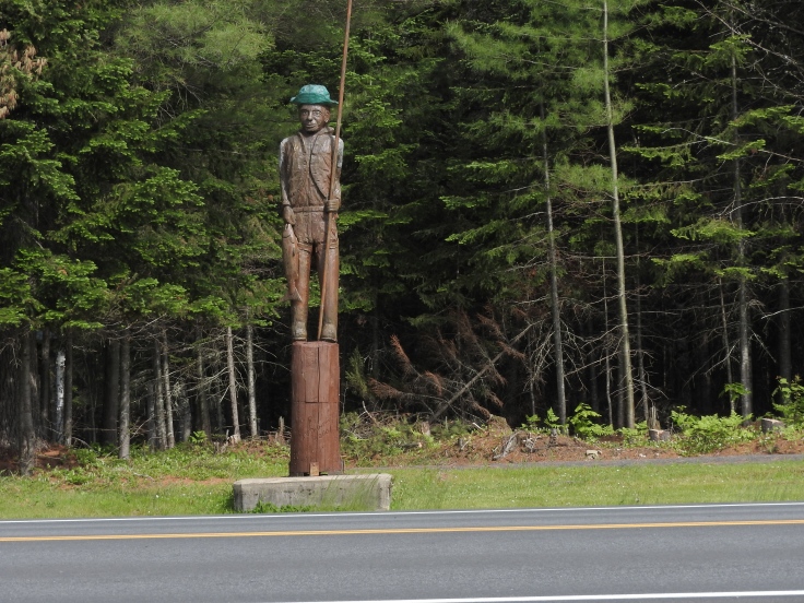
Albert the Lumber Jack is on the lawn and the Big Axe is on the roof. The building resembles a chunk of wood requiring splitting, It is not going to fit in the wood stove like that.

The wood carved Lumber Jack, is across the road.

The Fisherman is also across the road, the Lumber Jacks neighbor.
Peerless Self Oiling Lombard steam Engine across the road near the edge of the woods.

Just before the Woods Man Museum is the Boistown Community Park it has a 1 kilometer trail, a play area for the kids, johnny on the spot toilets and a generous parking area. You’ll see an air craft at the entrance.
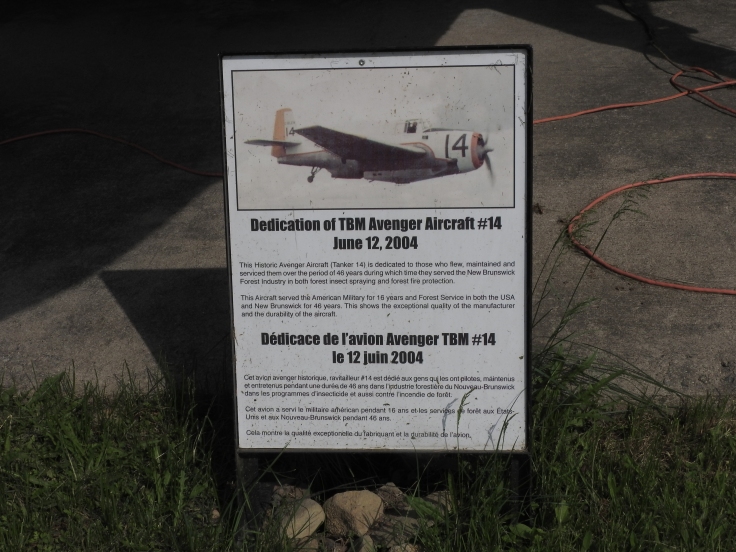
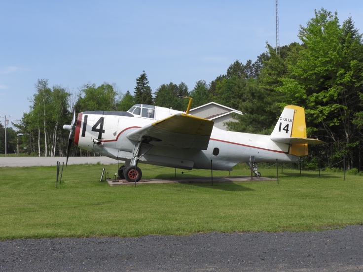
TBM Avenger Air Craft #14, is a great addition I got lots of great pictures. We have more to see so lets keep going up the road.
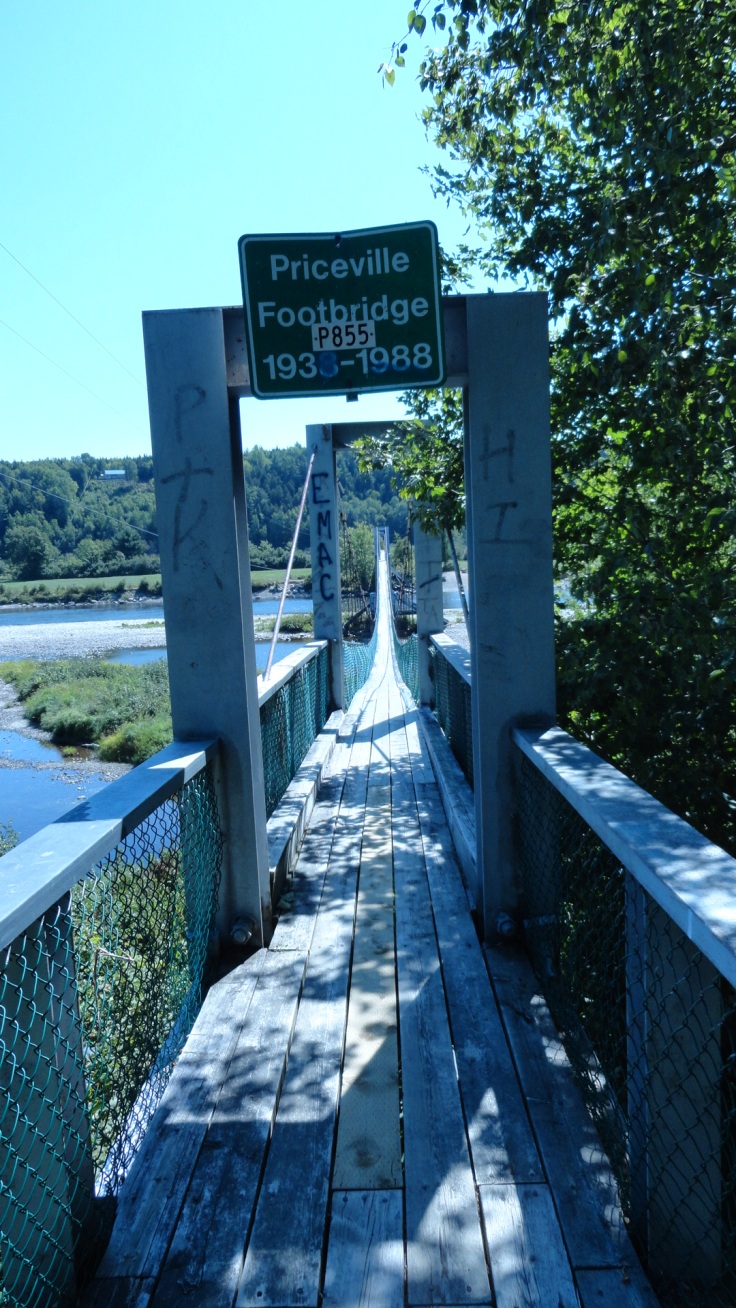
The Priceville Suspension Foot Bridge from Highway 8 you can either turn left on McNamee Road follow it for about 4 km, it turns into Carroll cross-road, follow it for about 650 meters on your left you will see sign for Priceville Foot Bridge. Alternatively, if you miss McNamee Road exit, you can continue to the next exit which is at Holt Road. Turn left onto it for 1.4 km (0.9 mi.), then you’ll turn right on Carroll’s Crossing Road for 0.6 km. It again is on left side of road. There is an interpretive sign just below stairs leading up to it that is worth reading. It tells of the flood of 1938, that swept away the bridge. The event is known as the Priceville tragedy. One man hung on for hours, three men lost their lives. Don’t worry, the bridge has been rebuilt of steel cables and maintained by department of highways so it is sturdy and safe to enjoy. I meet a man and lady walking the bridge to McNamee from Priceville, they told me they use it regularly to visit neighbors, it is very convenient and a bouncy delight.
You can also walk the river stone shore line and skip some rocks or just get mesmerized by the current. Take your time and relax. When you are ready to go we’ll catch back onto highway 8 the Miramichi River Route, and continue north. In about 11 kilometers we will come to the oldest covered bridge in the province located in Ludlow. Exit the highway at Lyons Lane on your left. It is a dirt road. I parked at the top and walked down to the bridge because access to it is via a rough scree grave hill and I am always concerned about getting my truck turned around on narrow road. You could drive down if you have a high vehicle but it is a short walk so why chance it.
Nelson Hollow Mill Brook Covered Bridge the oldest in New Brunswick 1900.

I believe the Sentier Trail connect with this bridge but I only walked a short bit. No rush take your time next we go to Doaktown.
Many of the pictures of the Miramichi display this scene from the bridge in Doaktown. park at the end and walk on the shoulder to the middle of the bridge for best shots, watch for traffic, the sides are narrow. You can also go down the road and walk to an area below the bridge. I saw several Mallard floating in a shallows.
Doaktown


Another thirty minutes up the highway is
Considered the Salmon fishing capital of the Miramichi. It seems fitting to have The Veterans Fly located at the corner of Main Street and South Bartholomew Road, for all to see.
Blackville municipal Park located at 12 Bartholomew Drive
I actually stopped here for the visitor center and to use facilities, but I discovered a whole new awesome place. I pulled into parking lot and 70’s music stretched all the way into my open window. Smoke rose from the open barbecue as a man in front of it rotated wieners to their uncooked side. A celebration gather was going on under the covered picnic area my guess was an anniversary but could have been a family reunion. I was tempted to join in, I figured I could have slide in quiet easily but I’m not a hot dog eater so I set my sites on walking the path down to the river.
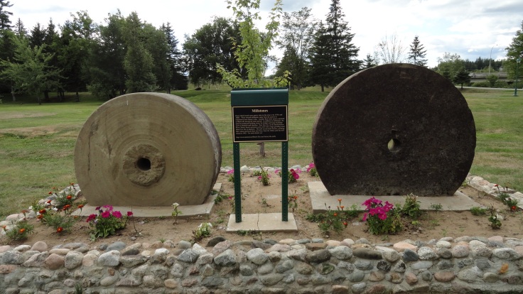
I stepped out of the of the way of a faster moving bicycle as I sauntered along. I could see the trail that led under the bridge was cordoned off. Trucks where moving around and men where working so the area looked to be closed for maintenance. I walked over to a wooden lookout to the river. Steady rivulets of water rolled over the rocky bottom. I linger for a moment to take some photos, but some tall trees along the bank and direct sunlight was not going to make for great photos. Back to the path I see some flowers in the planter boxes. I am not a botanist but I appreciate the summer colour. Two Large round stones catch my eye. Unused mill stones set here as local historical markers tell the story of active grist mills and local entrepreneur Henry Reid.
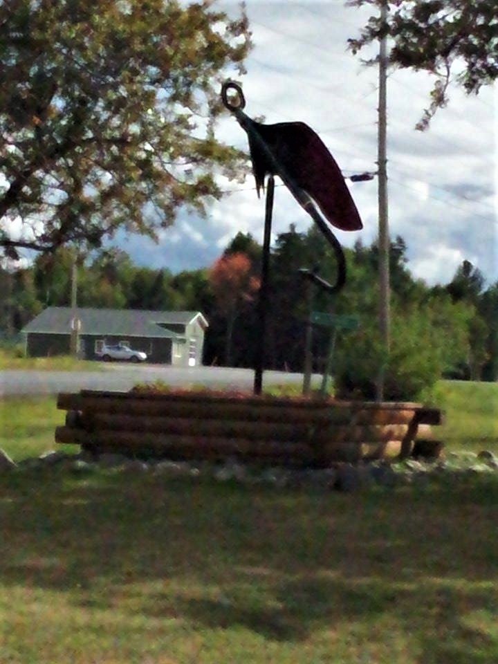
A few more planter boxes and I head back to my truck. On the drive out I see a statue and I have to get out and investigate. The Legend of the Dungarvon Whooper. The story goes a young handsome cook with a bellowing voice and a stacked money belt, died under suspicious circumstances in his wood camp. Legend has it he is said to still haunt the area to this day. I wish him peace, take my photo and smile at the comical rendition of a cook hollering holding a frying pan.


We’ll head north to Quarryville and take the 415 exit, then left onto the 420. It is about 25 kilometers to:
Red banks


Our last stop is one I have wanted to do for several years and I finally made it this year. Checking off all my travel boxes; National Historic Sites, outdoor exploration, mysteries and oddities. The Heritage center pieced together the phases and lifestyle of the Indigenous people of the Miramichi River Route that has lived on or near its banks for over 3000 years. A reflection on their history, and culture of sustenance living on what the region provided. You can’t actually visit the Augustine Mound or Oxbow site but you do get a sense of pride and respect for the special locations;.The whole place is well done and It was worth the visit. I recall thinking what a splendid lifestyle; No deadlines no sales goals no mortgage to pay ahhh. Back to reality and back on the road.
We will follow the River along the 420 for a twenty three kilometer drive for our approach to Miramichi. The scenery is relaxing take your time and enjoy the unhurried drive. I will leave you to explore all that the Miramichi offers. You can check out Top 20 Maritime Outdoor Escapes for some of the gems of the area. Until next time
Happy Travels from Maritime Mac

Contribute
If you like this content you can tip me to show your appreciation. and ensure the continuation of this blog
C$2.00


Hi kelly,
Hope all is well. How contacted you about Nancy? What happened ?
Get Outlook for Android
________________________________
LikeLike
Thanks for checking out my blog!
LikeLike
I’m always search for inspiration and good content, keep up the great blog, and thanks for visiting my blog Ena, cheers
LikeLike
Howdy outstanding website! Does running a blog such as this take
a great deal of work? I have very little knowledge of computer programming but I had
been hoping to start my own blog in the near future. Anyway, if you have
any recommendations or tips for new blog owners please share.
I know this is off topic but I just had to ask. Thank you!
LikeLike