After doing The Fundy Trail Parkway, Is Not The Fundy National Park.. I had no idea I could follow it up with Walton Glen Gorge…….ous.. Then I rambled up the Sussex Bluff. The Hike Part 3. Now I am completely hooked on hiking to look-offs and from the response to these posts, you are too. I know just where to take you next- Welsford.
A little over half way between Oromocto and Saint John’s on Highway 7. Take exit 63 Welsford / Fredericton Junction. This small community has a lot of offer.
Welsford Golf Course I rarely mentions attractions that cost money but this is a big attraction in the village, so this attraction, will appeal to only those that golf. I am not a golfer, but I am an armchair fan. I enjoy watching the majour PGA tournaments and keeping up with the leaders. Every times I pass here I think, wow what a pretty back drop for a round of golf.
I walked into the club house and spoke to the owner Alastair Barr, and asked if I could have a walk around his course and take a few pictures. He was very agreeable said “You missed the best of the fall colours.” They still look outstanding to me. If you are in the area, stop here for 18 holes embedded in beauty in every direction.
Road Side Attraction. From Eagle Rock road, turn right at the Irvin station onto Highway 101. On the right hand side of the road, is a life-size carving of an eagle on a pole.
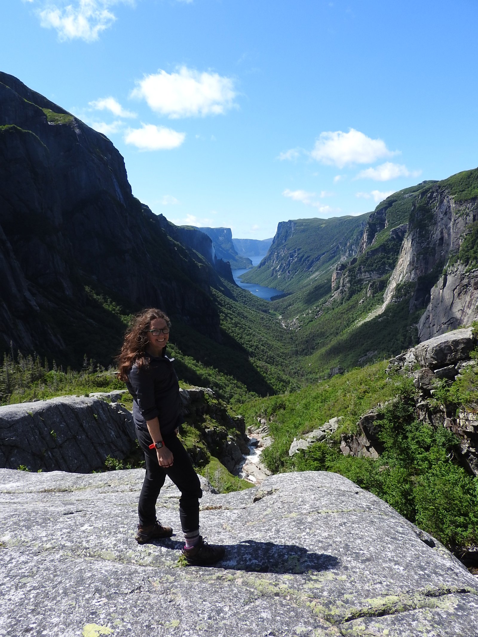
Bald Mountain. Take Highway 101 through the village and drive under the overpass. The first right is Burton Lane. The trail head is the clearing through the trees. A rock exposed foot path, that is steep at some segments but I would say reasonable for people with an average fitness level. It was about 40 minutes up give or take, I was in no rush.
Expect to share the trail with others. I saw a lot of dogs, plenty of children, and a few toddlers in their parents backpacks. The first ledge I came to had some campers, their tent pitched among the trees and the pair were cooking breakfast out on the bluff. You can’t miss the wall of rock in front of you. Turn and follow the path up the back.
The reward is a minute away. You can walk on an enormous flat rock on the top of the world.
Welsford Falls, turn right onto highway 101. Go over the train tracks, past Sullivan’s road take the next left. The road has no posted name. Follow it for about 1 kilometer. It is a broken-up paved road,popular with the four wheeler crowd. Stop at a wooden culvert, the trail is off to your left. There is two parts; the upper falls area and farther down the trail is the lower falls. The first photo is from this spring after a heavy rain, and the second was taken this fall after a dry season. It is very beautiful but be careful. These pictures don’t show the depth down to the river. The bank is loose gravel.
Douglas Lake Continue your journey down highway 101. Douglas Lake is accessible from the road. I followed a beat down path to the shore line. Looks like potential canoeing and fishing here. Its is a delight for photographers.
Clarendon Falls 1. If you continue north on Highway 101 past Douglas lake you will come to sign that says Clarendon and then Wirral. It is 14 kilometers outside Welsford, which translates into a ten minute drive from the community. You can park just past the bridge at the wide gravel space. Walk back to bridge and look down. There is some great rock formations to be seen. I got up close because it has been very dry this summer. I doubt I would get these photos after a heavy rain.
Clarendon Falls 2. You’ll have to hike the path beside the falls up the into the woods for about a kilometer. The trail gradually narrows and becomes harder to find. Look for the orange ribbons tied on branches to complete the trail. A little tricky to keep your eye on the markers, while you are trying to choose which boulder is stead enough to put your weight on. This is Clarendon Falls number two.
Cochran Lane. Return back to the village of Welsford. I want to shout out a thank you to Linda at the Irvin station. She was very helpful answering my question and getting me directions even calling on customers for knowledge. Stop in and say Hi from Kelly. You are now going to turn right onto Eagle Rock Road, go by the fire station and take the next left Cochrane Lane. It is a single lane over what use to be a covered bridge, so I was told. You’ll come to a big farm, park on the shoulder don’t block the driveway. You can see the worn path in the grass, follow it up to the tree line and enter the forest.
Some generous people have built stairs into the hill to help with the hike up.
Just when you start thinking you are lost, you’ll come across some signs to guide you.
A couple of young men carrying heavy packs caught up to me. I stepped a side to let them pass. I came here for a hike but this is serious climbers country. A box nailed to a tree had first aid supplies in it.
The views are wonderful from up here, even if you are not a climber.
Coming back down the path, I found some few friends.
What is a farm without some sheep and a beautiful pond for a back drop.
Eagle Rock Park. We have one more stop. Head south on Eagle Rock Road for about two and a half Kilometers. On the right side of the road is a small picnic park. Placed at the base of a mountain the mature trees are grand and widely spaced. A challenging walk up for those that dare try. I only went a little way because of the leaf litter. I struggled to come back down without doing it on my butt.
Please join me for part two of; The Best of Series. as we continue on down the road to Westfield and Grand Bay, in our next adventure.
Happy travels from Maritime Mac
Tip Me
If you like this content you can tip me to show your appreciation.
C$1.00


Welsfort seems like an awesome hiking destination. I fell in love with the scenery! How many days would you recommend staying there?
LikeLike
I would say 2-3 minium, and the next town over is 10 minutes away, I’m doing story on it next, so much to see and, do, there is a cycling and hiking trail linking the community,
LikeLike