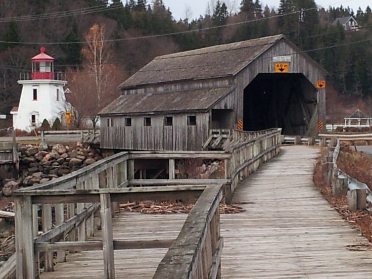
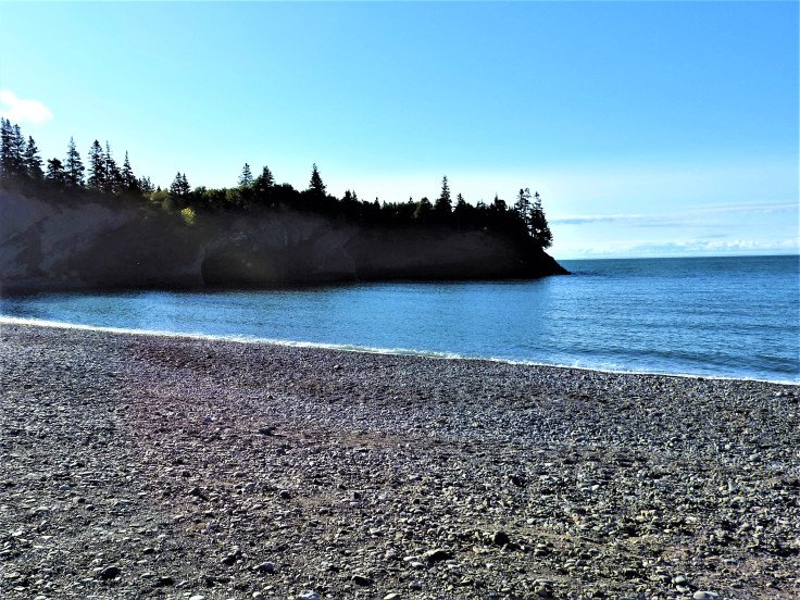
I have been to St Martin’s beach in southern New Brunswick many times, it is a little over an hour from my home. I, like everyone else, stop and take photos of the two covered bridges, the lighthouse, and the fishing boats moored to the pier resting on the sea floor.
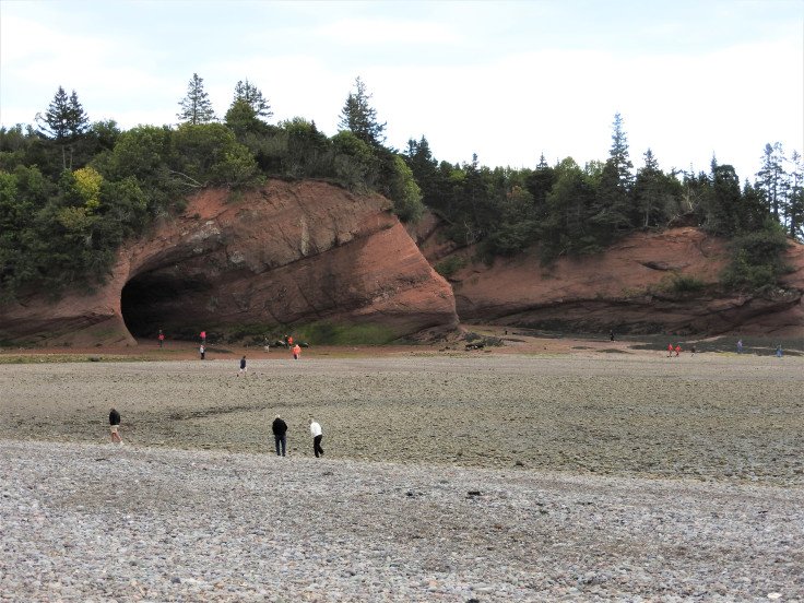
Then continue on to the sea caves to walk on the sea floor at low tide and marvel at what is revealed while the tide has receded.
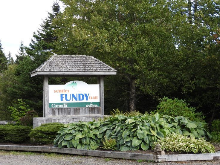
Just before the covered bridges is a sign that says Fundy Trail with an arrow pointing forward. I have looked for the trail head on each occasion I have been here. Focusing my search to the area between the covered bridges and the sea caves. I have come to believe I would never find it unless I acquired a pair of ruby hiking boots that I could click my heels together and wish to see it.
I finally decided to ask a local man at the gas station in the village. “Where the heck is this Fundy Foot Path?” He said ” just go up the hill past the sea-caves.” Up the hill, up what hill? I ask myself. Doesn’t the road end at the caves? ” just keep going” he says, seeing the bewilderment on my face. Apparently the caves are so aw-inspiring that I have never looked beyond them.
I slowly round the bend focusing only on the road trying not to look at the sea caves in case they are some siren of the sea bewitching me so I wouldn’t see the hill. Magically there it is. I swear I have never seen that hill before. It materialized right then and there.
Keep going. His words echo in my head. Approximately ten kilometers down the road past construction, I come across a sign followed by and entrance booth.
I tell the Lady I had no idea this was here. I said,’ I am ashamed to say I am a martime travel blogger and I had no idea this park was distinct from the Fundy National Park”. My Canada 150 National Park pass doesn’t apply and I have brought no cash. I offer debt, she says “we take debt but just wait a moment.” She calls the office and speaking into the phone. I hear her say “she’s’ a travel blogger, can I let her in?”. She hands me a map and drops the name Nancy Lockerbie, “she wants to see you at the interpretive center. ”
“Where is that”? I ask, “keep going you’ll see the sign”. I am awe struck by the scenery, I want to stop but I have to find the interpretive center it is already 2:40 pm. I drive the posted 40 km speed limit. Several step grades of 13% to 15% have me putting the truck in low gear, it hearkens back to the drive around the Cabot Trail. I find the sign pointing to the Interpretive center. I am still dumbfounded that this place is undiscovered country to me.

Nancy Lockerbie the manger, greets me and asks what I will be writing about? I tell her this park has been completely off my radar, how is that possible? I usually write maritime intrinsic travel pieces. I came her to locate the second suspension bridge in the province for another piece I am working on, and to do a little hiking on the Fundy foot trail.
She explains most people see The Fundy Trail Parkway and mentally link it with the Fundy National Park. The Fundy Trail Parkway, is a scenic drive. It is not the Fundy National Park. It is operated by a non-profit organization The Fundy Trail development Authority Inc. that manages this beautiful track of provincial Land. It is neither a National park nor a Provincial park, but a separate third party entity. That is why there is a fee to enter to help support the operation, and why it is not designated as a park on most maps. However, there is coordination from all levels of government currently progressing to link the Fundy Parkway with the three biggest tourist draws in the province; the Fundy National Park, the Hopewell Rocks and Cape Enrage
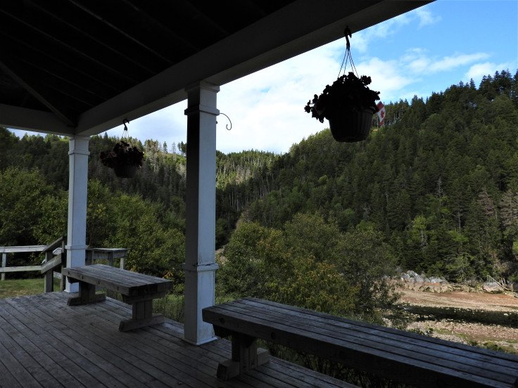
She gives me a bit of a history lesson, ” there was a complete community here once. ” We go out to the porch and she tell me the story of the logging and shipping that took place here, and expressed a genuine empathy for the employees of the time that worked in dangerous conditions. She points out the sluice way and a few logs-remnants of days gone by. I ask “what happened to the buildings are there any remaining”? She said there were two moved to Park street In St Martins. I make a mental note to check them out.
We look at some blown up photos displayed on the walls with descriptions beside them.
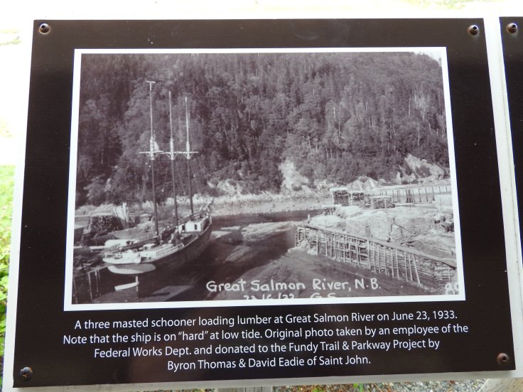
I find it hard to believe large ships came up here and such active commerce took place. There is a lot to discover here but it is late afternoon now I want to a full day to explore the region. I ask if I could return tomorrow, as I want to see most of the park and since there is no camping in the park, I have to return to St Martins to find a place to stay.
We shake hands again and She thanks me for stopping in. I thank her for having me here “I will do my best enlighten my readers to this beautiful place and distinguish it from the Fundy National Park. She points out a few trails on my map, first timers should try. The closest is the Suspension bridge, which is just a short walk down the path, I push open the door and wave so long.
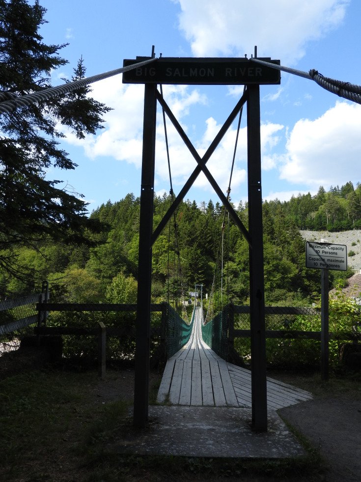
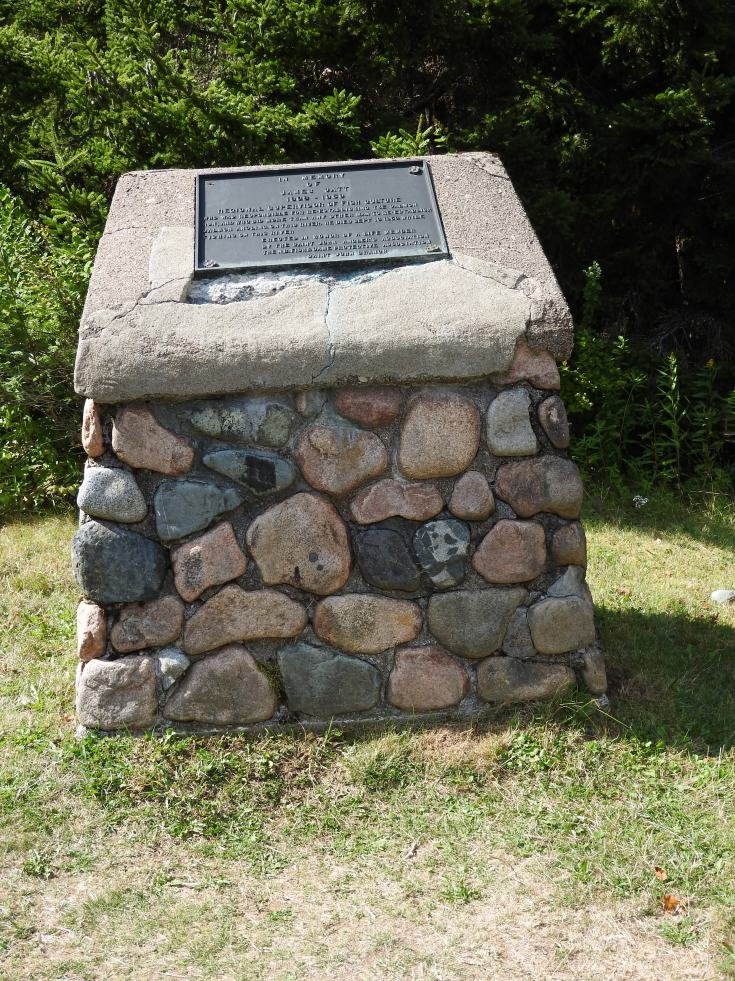
I bounce across with a smirk on my face, you can’t help but feel like a child on a trampoline walking across. I wonder around a bit, spying a monument. James Catt a fisheries officer.
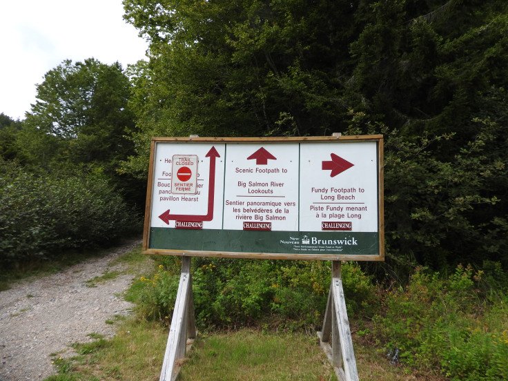
and sign posts for various trail directions.
I still haven’t quite clued into where the 49 Km Fundy Trail starts. I snap some pictures and head back to St Martins to find a campground.
Next morning I am at the gate at 8:55 am. The custodian is just getting out of her vehicle balancing a cup of coffee in her hand while she bumps the car door closed with her hip. I give her my name and details of my visit, then ask, ” where is the trail head?” She looks at me like she has not idea what I talking about and say “well the trail starts right here” and points to the open path through the trees. “Thanks” I follow it back to a locked gate. I figure this can’t be it, it would have more fanfare than a locked gate. I am looking for a sign or plaque that marks the exact spot, something like YOU ARE NOW STARTING THE WORLD FAMOUS FUND TRAIL KM 0.
I pull out the paper map/guide to the park. I circle all the items I want to see; they are categorized as lookouts, points of interest, hiking paths.

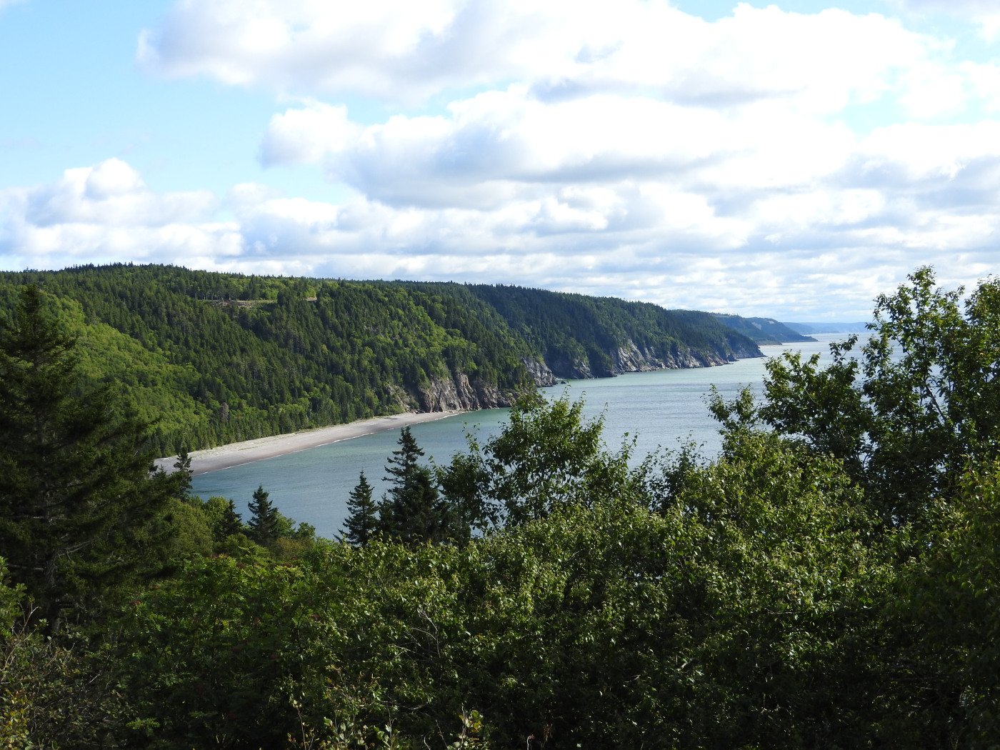
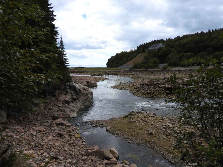
Fownes Head look off is a show stopper. Wow is that a gorgeous piece of land. Everyone has to come see this place. The picture is nice the real thing is breathtaking. This is also my first hike of the day the 1.5 km Flower Pot Rocks Scenic Footpath. I wander along looking at the interpretive plaques given descriptions of the ecology of the area. There are three observation decks to view the flower pot along this hike.

Next hike, The Sea Captains Burial Ground foot path. I can’t resist a graveyard. Looking around I can understand why someone would want to be laid to rest here. I walk up the stairs hunting around in the woods a bit before I zone in on the picket fence surround the sacred ground. There are two family burial plots: the Fownes and Melvin families. These two families owned ship building companies, where captains and owners of the land now included in the park.


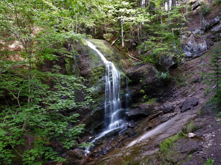
Next up Fuller Falls. I am really starting to enjoy this place. A hikers’ paradise with some hidden mysteries to seek out. The cable stairs leading down to the lower observation deck, would not be suitable for anyone with mobility issues; they are steep and wobbly, but a good view can be appreciated from above, so don’t fret. The summer has been dry leaving the falls a bit weak but still beautiful.
Pangburn beach is next. High tide is still going on so I skip the hike down and move onward to Black point, Hearst, and Pejepscot look outs; all equally impressive.
I head along to the interpretive center lookout which I showed earlier, then Tufts Point lookout which is lovely. Picnicking opportunities with a perfect view. The Hair pin turn is gorgeous but only for the passengers; keep your eyes on the road.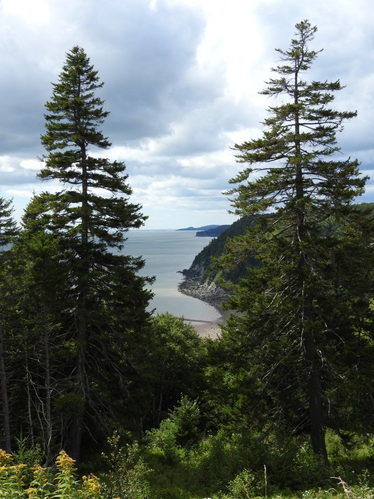
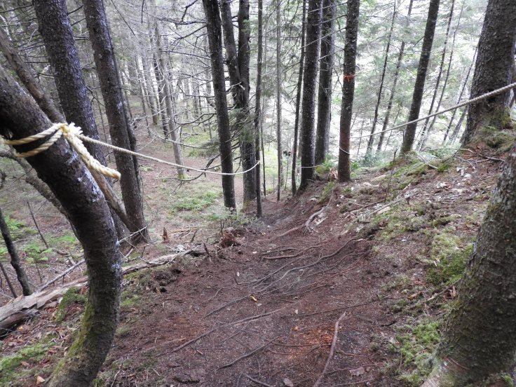
Forward to my next hike, Long Beach Brook Falls. I meet a couple on the trail, he is winded she is not. He stops for a breather and say to me “you have about another 15 minutes to get to the falls ” He asks his wife to show me the pictures. She replies with a ” she’ll see it” I thank him for the offer but “I like a surprise, and I am here for the exercise” He says “you have to go up this hill” with his open hand slanted upward depicting a steep grade. She wishes me luck and pushes her companion onward.
I come to the rope assisted hill he spoke of. It is steep but only a short climb in length so very doable for most people take your time.
I am pleasantly surprised with the falls I expected less.

I head back to the parking lot, the road is barricaded so no further driving is allowed. I recall yesterday, Nancy had said next year visitors will be able drive thirty kilometers. An extension being add to the current nineteen kilometers. I see a path to the left of the barricade. A large stone lures me. Does this mark the spot of the Fundy trail?
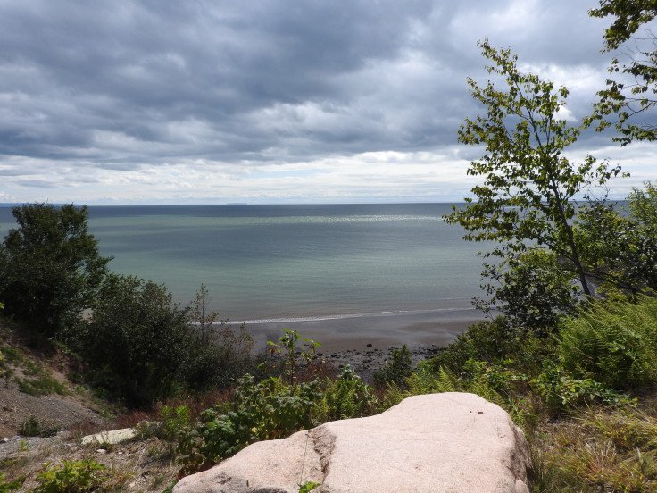
I pick a few ripe black berries and walk about a kilometer just to say I had walked on the Fundy trail. I have one more stop before heading back. Long Beach


There is a cold front moving in and the air has me chilled, so I spend only a few minutes here. I pull out my map/guide again and check off all I have seen. This is when it hits me. The red line is the driving parkway, check, the orange is a multi-use Trans Canada Trail check, The Blue is the The Fundy Trail
It all looks so clear now, It starts just beyond the suspension bridge and the first segment of the forty nine kilometer trail, finishes here at Long beach. I have to return to the interpretive center.
There is a direct road leading down to the suspension bridge. I park walk the short distant and bob across the suspension bridge once again. Finally, I see what I should have saw yesterday. The marker. It is unassuming not a grand impressive tourist attraction. I had been looking for. I wanted a large monument marking the spot for selfies. I guess the entrance gate sign will have to do.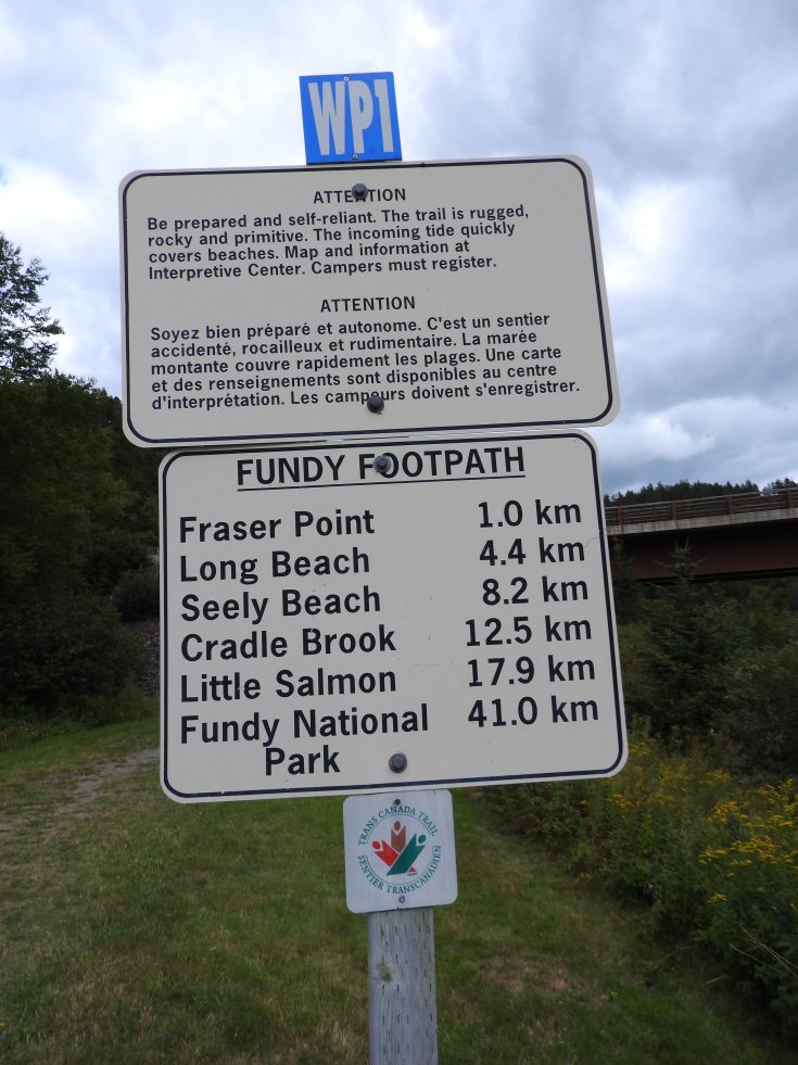
I try the first segment to Fraser point but stop short at a steep embankment. I have covered a lot of ground already today. I get one last picture of the trail and head back. I can now say I have done the first and the last kilometer, of the first segment of the Fundy trail.
I also take a walk to the water fowl observation deck along the shore line there is a group of people strolling on the beach, they have a guide who is herding them to the observation deck stairs. They allow me pass. I head up to the cookhouse, saw mill and view the foundation to the Big Salmon community school.Which reminds me I still have to find the homes moved to ST Martins from Big Salmon river.


Finished my hiking for the day I am hungry and fatigued. I can satisfactorily say I have covered most of the highlights of the The Fundy Trail Parkway. I will head back to St Martins, and located the Park street homes I will stop at the museum to see if they can tell me the address.More to follow. Maybe I’ll stay another night but looking up at darkening clouds rain is upon me I’ll probably go home; I have to tell the world where I was and what I saw. Everyone needs to know.
Cheers and happy travels from Maritime Mac.
Tip Me
If you like this content you can tip me to show your appreciation.
C$1.00


Great read and photos, thank you for sharing! 👍🏻💕🇨🇦
LikeLike
thanks John, Glad you enjoyed it.
LikeLike
You are welcome,
LikeLike
It’s almost a little eerie isn’t it! Love the pics!! xx
LikeLike
Don’t know how I missed your responses but thanks so much for dropping by, cheers
LikeLiked by 1 person
Interesting! We visited Nova Scotia a few years ago, but not New Brunswick. Some day! Thanks for visiting The Glasgow Gallivanter.
LikeLiked by 1 person
I was born and lived in Halifax region till I was 7, then moved to Cape Breton, I consider that home, but I live and work current in NB so I am using it as my platform mostly but I go to NS to visit family couple time a year and PEI,
look forward to hearing about your journeys, travel safe
LikeLiked by 1 person
Bit like that bridge in Beetlejuice. Why do they have those covered bridges in USA/Canada?
LikeLike
Every person i asked thought it was to protect bridge floor from weather so they last longer, my theory is to keep horses pulling carriage, from spooking from noise and site of the river
LikeLike
Thanks for the info…the Bay of Fundy is on my visit wish list.
LikeLike
You are so welcome. if you have any question or are looking for info, I may able to help out. cheers
LikeLike